
The PPRN (Plan for the Prevention of Predictable Natural Risks) in force of the Collectivity of Saint Martin is a multi-risk PPRN which takes into account the cyclonic hazard, the flood hazard, the ground movement hazard, the seismic hazard and the hazard soil liquefaction. This PPRN was approved by prefectural decree n ° 2011/009 on February 10, 2011.
On September 6, 2017, Cyclone IRMA, a category 5 hurricane, devastated the island of Saint-Martin. This event, unprecedented in its power, generated winds, a rise in sea level and a swell which resulted in flooding by marine submersion of large portions of the island territory.
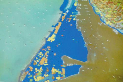
Following the passage of the hurricane, a map of the marine submersion hazard generated by Irma was quickly produced by Cerema. Its superimposition with the mapping of the cyclical hazard of PPRN in force revealed that the flood generated by Irma on certain parts of the territory, greatly exceeded that provided by the cyclonic hazard of PPRN.
On November 30, 2017, in application of article 14-12 of the town planning code of the community of Saint Martin, the prefect informed the community:
• the map representing the flood generated by Irma with four water depth classes;
• the updated PPRN cyclonic hazard map incorporating the heights of marine submersion water linked to Irma;
• the instructions for reading and interpreting the above-mentioned card.
In his statement made on the occasion of his official visit to Saint-Martin on September 29, 2018, the President of the Republic requested that the PPRN of Saint-Martin be revised from 2019. The State and the Ministry of Ecological and Inclusive Transition have set the following conditions for the revision of this PPRN in 2019:
• The revision of the PPRN will be limited to the sole risk of marine submersion linked to a cyclone,
• The hazard used will be the card used in the framework of the knowledge-raising (cyclonic hazard of the PPRN in force updated with information from CEREMA on the IRMA event)
The schedule for the PPRN review:
• Half April : Public meeting to present the mapping of the cyclonic hazard and the challenges Beginning of May: Public meeting to present the regulatory zoning and regulations for the cyclonic hazard
• June 2019: Order of approval in advance and annexation to the urban planning document
• Second semester 2019: Public consultations and inquiries
• End 2019: PPRN approval
The changes related to this revision are as follows:
• Creation of a new cyclonic hazard map: taking into account the heights of marine submersion caused by IRMA
• Realization of a new zoning of issues recommended at national level
• Implementation of a new regulatory zoning: intersection of the hazard and the issues (national recommendation)
• Implementation of a new regulation (national recommendation)
The objectives of the PPRN review:
• Reduce the vulnerability of the island's population
• Improve the resilience of the territory
• Promote the sustainable development of the island
• Reduce the impact of hurricanes
7,025 total views


No comments