


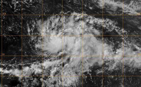
Current Situation
At 8 a.m. this morning, the center of Tropical Storm Philippe was located approximately 90 km west of Saint-Martin. (18.3°N and 63.5°W). The storm moves more sharply towards the northwest, and it brings its rains and storms in its wake.
Expected development
Heavy rain and thunderstorms:
The showers intensify this afternoon and take on a more lasting character. They remain frequent the next night. Significant accumulations are to be feared in a short time (40 to 60 mm in a few hours) but also over the duration of the episode, where accumulations could reach 100 to 150 mm.
Thunderstorms are likely to persist until Wednesday inclusive.
Wind gusts of around 90 to 100 km/h are possible under the heaviest showers.
Strong winds:
The wind, currently from the south-southeast sector, should move gradually to the southwest with speeds of around 35 to 45 km/h on average and gusts of up to 90 to 100 km/h at the strongest. showers, the unusual direction still to be taken into consideration. It should take a more southerly direction during the night from Tuesday to Wednesday and start to weaken.
Submersion waves:
The seas are rough in the Atlantic with waves of 2m50 to 2m70 due to an easterly swell crossed with an unusual south-southwest wind sea. Breaks and localized flooding are expected and boat anchorages will be in demand. Small-scale invasions will be observed in the harbor of Gustavia.
2,453 total views


No comments