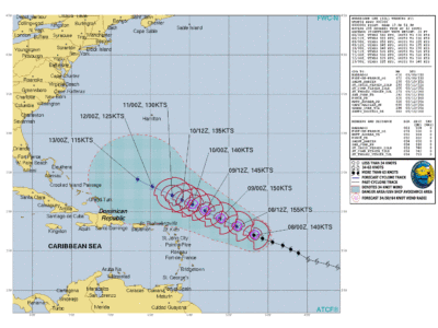
As expected Lee stepped up with a well defined eye. The orientation of the trajectory remains in very good agreement with the forecasts.
Lee is expected to continue heading west-northwest, gradually slowing its forward speed. According to the latest forecasts, it is now almost certain that the center of Lee will pass “well north of the Leeward Islands” according to the NHC, more than 400 km north of Saint-Martin, with a very strong associated swell which will affect our coasts. The winds in the center increased from 140 km/h to 260 km/h in 24 hours, a very rare acceleration according to experts.
Warm ocean waters near 30°C, lower wind shear and a humid environment contribute to this rapid intensification. In fact, water temperatures in this part of the Atlantic Ocean reached a record high in August.
Note that the strongest winds as well as the rains are located north of Lee, that is to say on the opposite side of our islands.
Forecast winds will exceed 150 kt or 280 km/h with gusts to 330 km/h on Friday and Saturday which will move Lee to category 5. The NHC intensity forecasts have been significantly revised upwards with risks for the Bahamas and the US coast.
So no boat trip this Friday and the following days until the sea calms down. Also beware of swimming, which is best avoided for a few days.
Winds will be moderate given the great distance from the center but showers will be possible.
The question we must ask ourselves: what if Lee had passed over St-Martin like Irma did in 2017…? Let's prepare ourselves even better, this time it's not for us but...
Visit our site www.faxinfo.fr for the latest news from Lee and official press releases from the authorities.
5,334 total views


No comments